Page 1 of 1
Mapping places from new, large TMG project
Posted: 07 Dec 2019 19:07
by LynnAnnMcLaughlin
As soon as I bring in a GEDCOM or TMG project, be it quite large (22,000 people) or small (208 people), and try to Map All Places, every single place in my list immediately gets a question mark, meaning the geocoding failed. Is there a strict formula for place names? Here are some examples of my place names with the parts as shown in the Place List:
Part 1: 100 Grove St., Part 2: Greensboro, Part 3: Guilford Co., NC
Part 1: Amherst, Part 2: Amherst Co., Part 3: VA
Part 1: Amherst Co., Part 2: VA, Part 3: blank
Part 1: Bristol, Part 2, England, Part 3: blank
I also went into the Sample project and removed GeoCoding from a couple of places and got the question marks. Now I can't find a way to get geocoding back. So is part of the deal that once it fails, it will never try again?
Does it ever really work? I think the Sample Project comes in with the coding already set. After resetting the project, I added a residence for on person of Dunedin, New Zealand since it wasn't already there, and the format was identical to the existing record for Auckland, NZ, then tried to map all places for that person. Again, just a question mark.
What is the internet service that FH uses for geocoding? I know my connection to the internet is working, but maybe it is my connection to that service, or that service is down. How can I check?
I am using Family Historian version 6.2.7 on a Windows 10 laptop.
Thank you very much!
Lynn
Re: Mapping places from new, large TMG project
Posted: 07 Dec 2019 20:55
by tatewise
Welcome to the
FHUG Lynn.
That is very mysterious. Usually the geocoding works quite well, and there are problems with only a few Place names.
The fact that it does not even work well in the
FH Sample Project is concerning.
Please try this experiment in the
FH Sample Project in the
Map Window for all
Map All Places.
- Select Auckland, New Zealand
- Either right-click or use Map and choose Geocoding > Remove Geocoding
- That should show the ? mark and remove the Latitude/Longitude values
- Either right-click or use Map and choose Geocoding > Refresh Geocoding
- That should show a tick and generate the correct Latitude/Longitude values
Let me know what happens.
Whereabouts are you located? Maybe it is something to do with where you live?
The geocoding services are identified at
https://www.family-historian.co.uk/geocoding.
See also the
Help > About Family Historian details.
Re: Mapping places from new, large TMG project
Posted: 08 Dec 2019 02:38
by LynnAnnMcLaughlin
Thanks for your reply, Mike. I did a reset on the sample project, then tried your suggestions. Removing the geocoding on Auckland changed the checkmark to a question make and got rid of the coordinates, but refresh did nothing at all.
I'm in Warwick, Rhode Island, USA.
The link you provided, which I'd earlier found with google, says, "Family Historian uses map search and geocoding services provided by Algolia. Map search and geocoding in Family Historian is also powered by the OpenCage Geocoder," while the help from doing F1 says it is provided by Edina. Edina is just for UK university people, so I can't do a stand-alone test with that. I tried the free trial for OpenCage, and it worked fine, and I was able to put simply, "Warwick, RI" or "Auckland, NZ". Algolia seems to be very business oriented - it looks like I can request a demo and have a sales person contact me, which isn't at all what I want.
I could do a Places report on my DB, put all the places into a spreadsheet and get their coordinates, but then is there a way to bulk enter them into FH? That isn't ideal, of course!
thanks, Lynn
Re: Mapping places from new, large TMG project
Posted: 08 Dec 2019 02:48
by BillH
Lynn,
I also live in the US so I thought I'd give it a try and see if it was still working for me (it always has in the past).
I created a place called Warwick, Rhode Island, USA and tried to plot it. It worked just fine.
So it doesn't look like the problem has anything to do with being in the US. I wouldn't have thought that made any difference, but I just wanted to rule that out. Hope you are able to find a solution.
Bill
Re: Mapping places from new, large TMG project
Posted: 08 Dec 2019 02:58
by BillH
Lynn,
I just had a thought. If you go to Tools > Preferences > Map Window > Preferred Map Type, what is yours set to? I have always had problems with using "OSM Roads". It can't seem to even bring up a map for most places I plot. I use "OpenStreeMap". Not sure this would have anything to do with the problem you are experiencing since for me I don't get a ?... it just won't plot on the map.
Bill
Re: Mapping places from new, large TMG project
Posted: 08 Dec 2019 10:31
by tatewise
The
Preferred Map Type does not matter, and the default is
OpenStreetMap anyway.
The format of
Place names is often unimportant, e.g.
NZ Dunedin works Ok even though reversed and without commas.
I was going to suggest you visit those geocoder websites in case they were blocked for some reason, so it is not that.
It is beginning to look like some setup on your PC that is preventing the geocoding.
However, the first thing to try is to simply re-download and re-install
FH V6.2.7 over the existing installation.
Get the download from
https://www.family-historian.co.uk/down ... ee-upgrade.
Are you running in an
Administrator account or a
Standard User account?
Have you any additional security measures installed, such as a firewall, anti-virus, etc, that might block geocoding?
Could you temporarily inhibit them to see if that is the problem, or perhaps run
FH in
Safe Mode + Internet.
If all else fails try contacting
Calico Pie using their how_to:about#problem_reporting|> Problem Reporting Support Centre Ticket System.
Re: Mapping places from new, large TMG project
Posted: 09 Dec 2019 01:44
by LynnAnnMcLaughlin
I have the map type set to OpenStreetMap. Interestingly, the experiment with removing the geocoding for Auckland and then refreshing it in the Sample Project worked today. Then I tried it for one person in my big file, and it did great with Newport, Newport Co., RI, but put St. Louis, MO somewhere in Ontario, so that is a whole separate issue. Supposedly the default country comes from Windows, but I've set it in the Map Window preferences to US, and maybe that will help next time.
I tried again to map everything in my big file and it did quite a few. Knowing it would take awhile, I took a break, came back and woke up my computer, and saw a notification, "Geocoding service has been stopped. Server busy." There is a link to help which says it could be because of service problems or excessive use and that it will automatically re-try when the program is restarted.
When I wrote my original message, I didn't think that the fact that I'd tried to do the whole database and had had the service stop was relevant, so I didn't mention it. Now I think that once it stops, it is hard to get it started again. I've stopped and restarted the program, and I've also rebooted my PC, but it still isn't working. So the question has become, how can I get the service going again?
Re: Mapping places from new, large TMG project
Posted: 09 Dec 2019 06:53
by Valkrider
Try rebooting your router to get a new IP address, the server maybe storing IP address as overusing facility. A new IP address would overcome this if that is the problem.
Re: Mapping places from new, large TMG project
Posted: 09 Dec 2019 10:36
by tatewise
Sorry Colin, it is not the router, but it is service limits.
Lynn, pity you did not mention the original error message because that is crucial.
The
FH automatic geocoding is limited to a quota each day to avoid overloading the server.
See glossary:map_window|> Workspace 8: Map Window.
See the long thread
Geocoding stopped - almost all the time (16609).
Re: Mapping places from new, large TMG project
Posted: 09 Dec 2019 11:09
by Valkrider
tatewise wrote: ↑09 Dec 2019 10:36
Sorry Colin, it is not the router, but it is service limits.
Lynn, pity you did not mention the original error message because that is crucial.
The
FH automatic geocoding is limited to a quota each day to avoid overloading the server.
See glossary:map_window|> Workspace 8: Map Window.
See the long thread
Geocoding stopped - almost all the time (16609).
@Mike if they monitor the quota by IP address then resetting the router will result in a new IP address and so will overcome the limit.
Re: Mapping places from new, large TMG project
Posted: 09 Dec 2019 11:22
by tatewise
Yes, I see ~ it will be interesting to see if that works, or if the quota is tied to some FH licence code, etc.
( The quotas on the Google Maps Geocoder are tied to the Google Account. )
I forgot to say that setting Preferences does not force the geocoder to use a particular country.
The better way is to always include the country in every Place name.
If you need help doing that in bulk then just ask.
Re: Mapping places from new, large TMG project
Posted: 09 Dec 2019 19:20
by LynnAnnMcLaughlin
Thanks for the responses and the link. I set the flag to not refresh the non-tentative ones, and will wait until it has been 24 hours and then see if I get any more.
I'd be interested in knowing how to do a bulk upload of the country, or other data. I'm almost through the Getting the Most from Family Historian 6, and have found nothing about bulk uploading of specific data. In fact, since I now have a spreadsheet that will get me geocoded data, I wonder if I could put all my places there, get it geocoded, and bulk load it back.
Thanks, Lynn
Re: Mapping places from new, large TMG project
Posted: 09 Dec 2019 21:26
by tatewise
Lynn, could you please try Colin's suggestion of switching off and rebooting your router to get a new IP address.
Does that allow you to geocode a bunch more Place names without waiting 24 hours?
It is only with new users like you, who have thousands of Place names, that we get to experiment with these ideas.
You cannot bulk import data directly from a spreadsheet into
FH.
It is possible to use a custom Plugin to perform such tasks but is rarely worthwhile.
However, it is quite easy to use the
Search and Replace Plugin to add
, USA to every
Place record.
See plugins:about|> About Family Historian Plugins for advice about downloading from the
Plugin Store.
( BTW: Plugins only work in a fully licenced FH and not the 30-day trial. )
OK, so with the
Search and Replace Plugin set the
Search Scope to
Place Records and select
Place fields below.
Then select
LUA Pattern Mode which is similar to regular expressions.
In the
Search box enter
(.+) which captures everything in the Place field.
In the
Replace box enter
%1, USA which takes the captured Place and appends
, USA
Now click
Search & Replace and in subsequent dialogue check the
Replacement Value.
Keep clicking
Replace and checking each replacement until happy it is working OK.
Then untick
Confirm every item found and click
Replace again to convert the rest.
On completion there is a
Result Set of all changes, and use
Edit > Undo Plugin Updates to undo them all.
BTW: If only a subset of
Place records need changing then ask how to do that.
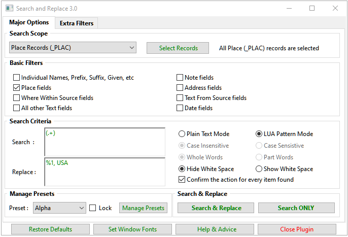
- SearcAndReplaceUSA.png (33.02 KiB) Viewed 9837 times
Re: Mapping places from new, large TMG project
Posted: 10 Dec 2019 03:35
by BobWard
Just to throw out a different workflow that avoids issues with auto geo-coding.
I manually geo-code all my Places. In most cases, I simply type in the name of the Place in Wikipedia and copy the listed coordinates into the Lat/Long box in the Place box in FH.
While I have the "Place" open in Wikipedia, I also copy the text that provides some history on the Place and paste that into the Note box for the FH Place record. So, whenever I open up a Place record for a Fact/Attribute in any individual's profile, I can read a good history lesson for each specific Place.
For verification purposes, I always select the "Map Places For xxxx" option after entering the Place geo-coordinates to make sure that it plots exactly to the correct location. Takes only a couple minutes for the whole entry process.
I also include street addresses in the Place record box, i.e., I don't use the Address box. When I am getting down to mapping Places with street addresses, I use Google Earth and zoom right in to the location to get a precise Lat/Long reading.
Re: Mapping places from new, large TMG project
Posted: 10 Dec 2019 10:31
by tatewise
That is great advice Bob, but Lynn has 22,000 people and I suspect nearly as many Place records, so doing each by hand would take her a long time.
I have looked at the geocoding of Newport, Newport Co., RI and St. Louis, MO.
Because I am in the UK, the FH Map Window initially plotted Newport in Cardiff, Wales, UK.
But even adding USA simply plotted it in the middle of the USA.
I had to change Co. to County giving Newport, Newport County, RI, USA to get it plotted correctly.
As you say, St. Louis, MO plots in Canada on a road called Montee Omer-St-Louis.
But adding USA to give St. Louis, MO, USA plots correctly in Missouri.
Re: Mapping places from new, large TMG project
Posted: 10 Dec 2019 14:49
by BobWard
I realize that may not be an efficient option for the OP. I threw that out as an option for those who may be starting new projects, or, for someone who may want to spend the time to update an existing database. If you adopt that approach from the beginning, its only a few minutes for each new Place record that is created as you build your family tree. Well worth the effort in my opinion. I have over 2500 Place records documented that way in my family tree. A real treasure trove of information.
Re: Mapping places from new, large TMG project
Posted: 11 Dec 2019 21:11
by LynnAnnMcLaughlin
As suggested, waiting some time helped the geocoding, but whatever it is using is disappointing. First that it doesn't know Co. stands for County, and that it won't use US for the default country even if I have it in my preferences. How do you enter a cemetery place? The Excel plug-in I'm using separately lets me put in simply Woodlawn Cemetery, Baltimore, MD, USA and it can find it. Everything I try wants to put in in Kansas, 1000 miles too far west. Strangely, all the places I couldn't find (which were all in the states of Maryland and Virginia) were assigned to the exact same place in Kansas, at 37°5'24.72"N, 95°42'46.44"W. Yet, it has no problem with just Clinton, MD, USA with no county, for example. It seems very inconsistent. I have the preferred map type set to OpenStreet Map. I guess it also can't find parks - for Leakin Park, Baltimore, MD, USA, it instead marked Leakin St. in Baltimore. I need to see the documentation on how exactly to specify places. Does anyone know where that is?
Thanks, Lynn
Re: Mapping places from new, large TMG project
Posted: 11 Dec 2019 22:37
by tatewise
Geocoding is something of a dark art, especially for genealogy where the older place names don't exist on modern maps.
It depends on the geocoder used, and some are better than others, but varying costs are involved.
As personal users we can use the Google Maps geocoder for free, but businesses like Calico Pie are charged a hefty fee.
So Calico Pie have a much cheaper licence to use the geocoders mentioned earlier, but they are not so good at finding streets, buildings, cemeteries, etc.
That is why I wrote the Map Life Facts Plugin that uses the Google Maps geocoder for free and can be synchronised with the FH Place records. Unfortunately, Google Maps now requires a credit card backed billing account with an API Key, even though the Quota Limits can be set to guarantee zero charges. I get an invoice every month for £0.00 which is crazy!
All geocoders are only partially influenced by preferences or your location, and will often prefer to pick a larger or more popular place than the one you really want. Their AI rules are somewhat obscure.
If a plot is in the middle of a country (Kansas in the case of USA) then the other parts of the Place name have been ignored.
There is no formal documentation for formatting Place names other than they are a comma separated list.
Prior to automatic geocoding, that was usually more than sufficient.
So the rules are governed more by which geocoder you are using, what resolution you want, and how you want to manage Place names.
For Place name management it is best to have a fixed number of comma separated columns.
So every Place will have exactly the same number of commas and some will have blank space between them.
Then in Tools > Work with Data > Places you set Columns to the desired number and ensure the right-hand comma separated Part always holds the Country so they can be sorted into order.
The next column Part would hold the State, and the next the County, and so on working left.
The higher the plot resolution you want will increase the number of column Parts.
For the highest resolutions you will include address details in the Place field and ignore the Address field.
The left most Parts will then define house/building name/number, the road/street, then district, town, etc.
Both the FH Place records and the Map Life Facts Plugin allow a Standardized/Substitute Place name to be sent to the geocoder instead of the displayed Place name. That allows modern locations to substitute for old places that no longer exist, or Zip Codes to be used that you don't want displayed anywhere else, or any other special names to be used that the geocoder likes but you don't usually want displayed.
I hope all that helps.
BTW: How did you get on with using Search and Replace to add USA to all your Place names?
Re: Mapping places from new, large TMG project
Posted: 12 Dec 2019 18:33
by LynnAnnMcLaughlin
Wow, Mike, you're really a fount of knowledge. I really appreciate all your answers!
I haven't tried the search and replace yet. I'm still trying to learn FH and evaluate it as my possible TMG replacement and want to do that without plug-ins to start with. I decided to start another project from scratch and since it is small, I can make the format changes easily to try to get the Geocoding to work.
I was wondering about the difference between place and address. Is Address for the part I don't care about Geocoding, for instance if I only want it to mark a town but want to record a street, cemetery, etc.? Do people fill in the full address there, duplicating the place (e.g. place = Warwick, Kent County, RI, USA and address = 100 Main St., Warwick, Kent County, RI, USA)?
When you said the rightmost column for the place should have USA, did you mean the rightmost used one or the rightmost possible one? In other words, if I adjust the places to have 5 columns for when I want it to geocode down all they way down to a street, then in the cases where I only have the town, do I need to remember to put in an initial comma? I'm happy to see that it doesn't include that extra commas in a narrative report at least.
thanks, Lynn
Re: Mapping places from new, large TMG project
Posted: 12 Dec 2019 19:36
by tatewise
Take a look at glossary:places|> Places and Addresses that answers some of your questions.
The concept of Place and Address fields is derived from the GEDCOM specification that FH supports.
However, GEDCOM dates from the 1990's long before geocoding was popular.
How people use those fields is largely a personal choice, and depends on what they want to achieve.
I gave some of the choices in my previous reply and the Knowledge Base article says much the same.
Some users put everything in the Place field and leave the Address field blank.
( Some genealogy products do not implement an Address field at all. )
Please read my previous reply again, because it says about leaving empty comma separated entries.
Also checkout the Tools > Work with Data > Places and try sorting columns. You will see what I mean.
If you define the Place field to have 5 columns the the Country will always be in the rightmost 5th column, and if you only know the Country there will be 4 commas on the left with just space in between:
, , , , USA
Most users won't usually repeat the Place details in the Address field, but there is a special case.
Imagine an event happened in St Marys Church but don't know the street, then Address just says St Marys Church.
If the USA is like the UK, there is a St Marys Church in different towns all over the country.
Now use Tools > Work with Data > Addresses and note that St Marys Church is only listed once.
It does not matter how many different Place names that St Marys Church appears under it is still only listed once.
So if you discover the Street for one of those churches in one Town, how are you going to edit just those without affecting all the ones in the other towns? The answer is to duplicate part of the Place name in the Address as explained in glossary:places#church_names|> Church Names, but it can apply to other locations too.